
Jeff Trapp, Ph. D.- NOAA/NSSL 02/10/00
Research Meteorologist,
NOAA/National Severe Storms Laboratory and
Cooperative Institute for Mesoscale Meteorological Studies
Boulder, CO

|
|
This
will be fun to analyze and explain! - DOW2 Log, 2/17/2000 Jeff Trapp, Ph. D.- NOAA/NSSL 02/10/00 Research Meteorologist, NOAA/National Severe Storms Laboratory and Cooperative Institute for Mesoscale Meteorological Studies Boulder, CO |
|
|
4:45
am DOW3 is still not operational, due to a faulty motor that controls the radar antenna rotation. I spent several days last week dealing with this problem: draining gear oil, cleaning contact points, checking voltages, and otherwise running diagnostic tests dictated to me over a cell phone by Steve McDonald. But, ultimately, it will require a new motor and Steve's expertise. Consequently, Luciano, DOW3's operator, is my companion today. 9:15 am 11:30
am
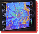
Within the snowband, the air motions deduced from the Doppler velocity are complex, consisting of vortices, zones of convergence, and waves. Jim would later show me a loop of satellite images of clouds that exhibited similar complexity. This will be fun to analyze and explain! One of Dave Rust's students is now here, and will escort Luciano to his abandoned, gas-depleted car, and then on to Grantsville for a fuel stop. Once he returns, we'll drive back to Salt Lake City, to where the most action now seems to be shifting, and deploy DOW2 once again to our site south of the airport (which, incidentally, is 1/2 miles from a landfill). In the meanwhile, I'm finally relaxed enough to eat my sandwich. 3:52 pm The air motions within the snow continue to be complex and a bit confusing. Unlike in the Tooele Valley, the radar scans now are no longer suggesting an obvious effect of the mountains on the snowfall. |
| Non-Flash Journal Index | This will be fun to analyze and explain! 1 2 |
![]()
 Jim Steenburgh called while I was away on a coffee run, and reported that
"it's snowing like crazy in the Tooele Valley." He had a "risky proposition"
that we redeploy there and collect data on a snow band. Since I've been
anxiously awaiting another chance to operate in snow (I took DOW2 out
for a trial run in light snow, during the early-morning hours of the first
official day of the project), without hesitation I shut down the computer
systems, and then stowed and strapped down the antenna; within 10 minutes
we were headed west on I-80.
Jim Steenburgh called while I was away on a coffee run, and reported that
"it's snowing like crazy in the Tooele Valley." He had a "risky proposition"
that we redeploy there and collect data on a snow band. Since I've been
anxiously awaiting another chance to operate in snow (I took DOW2 out
for a trial run in light snow, during the early-morning hours of the first
official day of the project), without hesitation I shut down the computer
systems, and then stowed and strapped down the antenna; within 10 minutes
we were headed west on I-80.
 Finding
a good radar site was challenging, to put it mildly! Ideally, we like
to find a level spot, off the side of a paved road, with unobstructed
views in all directions. Radar sites used during the other IOPs (IOP=Intensive
Observing Periods) were determined on clear, sunny, "down" days; today,
I was forced to site the radar while driving in moderate snowfall, with
snowplows whizzing by, and with the added pressure that we were missing
valuable data-collection time. The Erda Way Rd. site was in the vicinity
of a few trees, buildings, and telephone poles, which blocked some of
the radar beams when the radar scanned at low angles relative to the horizon.
But, it sufficed.
Finding
a good radar site was challenging, to put it mildly! Ideally, we like
to find a level spot, off the side of a paved road, with unobstructed
views in all directions. Radar sites used during the other IOPs (IOP=Intensive
Observing Periods) were determined on clear, sunny, "down" days; today,
I was forced to site the radar while driving in moderate snowfall, with
snowplows whizzing by, and with the added pressure that we were missing
valuable data-collection time. The Erda Way Rd. site was in the vicinity
of a few trees, buildings, and telephone poles, which blocked some of
the radar beams when the radar scanned at low angles relative to the horizon.
But, it sufficed.
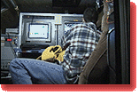 I'm
back inside DOW2's cozy little cabin after mopping the snow off the radome,
the protective cover of the parabolic radar dish. Snow or ice (or even
rain) on the radome essentially weakens the radar signal, which in turn
leads to a false impression about the intensity of the snow, rain, etc.,
well away from the radar. Snow is falling only lightly, so another radome
mopping probably won't be necessary.
I'm
back inside DOW2's cozy little cabin after mopping the snow off the radome,
the protective cover of the parabolic radar dish. Snow or ice (or even
rain) on the radome essentially weakens the radar signal, which in turn
leads to a false impression about the intensity of the snow, rain, etc.,
well away from the radar. Snow is falling only lightly, so another radome
mopping probably won't be necessary.