| S
h i r l e y M u r i l l o
 Hello, Shirley Murillo here. Here? You may be wondering
where here is. Well here is Miami, Florida. I'm a meteorologist and
work at the Hurricane Research Division (HRD) of NOAA. I study hurricanes
for a living and sometimes I even get to fly into them. Yes, fly into
hurricanes, but more about that later.
Hello, Shirley Murillo here. Here? You may be wondering
where here is. Well here is Miami, Florida. I'm a meteorologist and
work at the Hurricane Research Division (HRD) of NOAA. I study hurricanes
for a living and sometimes I even get to fly into them. Yes, fly into
hurricanes, but more about that later.
I
work with a team of meteorologists who examine the winds inside hurricanes.
Hurricane force winds range from 74 mph to over 155 mph! Winds this
strong are known to cause a great deal of damage to cities along the
US coast. During the hurricane season my job is to produce hurricane
surface wind analysis. We receive up to the minute wind data from ships
that are near the storm, buoys, satellites, and aircraft that are flying
in the storm. All these data are "adjusted to surface" which means that
with a little math we can get satellite wind measurements to tell us
what's going on at the surface. A computer generated map of the wind
field is produced. This product is then given to the hurricane forecasters
to aid them in detecting where the highest winds are located in the
storm and when tropical storm force winds (41 mph or greater) or hurricane
force winds (74 mph or greater) will make landfall. The hurricane forecasters
can also use the wind analyses to put up "watches" or "warnings" in
areas that may be affected by the highest winds in the storm. HRD produces
these wind analyses on a 6 hour basis, but when a hurricane is approaching
land, we go on a shift schedule (around-the-clock) and produce analyses
on a 3 hour basis.
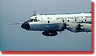 Once
a while, I get the opportunity to fly into these powerful storms we
know as hurricanes. Most of my family and friends think I have a wild
streak in me for doing this. What better way to find out what is going
on with a hurricane than going right inside one? A team of scientists
and the flight crew get to go on board a mission that most people tend
to shy away from. Our airplanes are equipped with instruments and computers
that help us measure the storm. We need to find out if the storm is
strengthening, how fast it's strengthening, where its headed, how strong
the winds are, and the location of the eye (the center of the storm).
Most of the data collect gets transmitted via satellite to the National
Hurricane Center (NHC). My responsibility on board has been to operate
two radars that are on the plane. When we get near the storm I start
recording images from both radars. If the Lead Project Scientist (scientist
in charge of the mission) wants to change the tilt of the radar, or
wants to make sure the data is coming in correctly, I'm the person he
talks to. I monitor and jot down any notes about the radar images I
see or anything that is going on during the flight (for example: "48
dBZ in eyewall", "symmetrical eyewall", "very bumpy near eyewall...
almost spilled my soda!"). The best part about the whole trip for me
is getting to the center of the storm (the eye). Most of the time the
eye is the most peaceful part of the storm. Once
a while, I get the opportunity to fly into these powerful storms we
know as hurricanes. Most of my family and friends think I have a wild
streak in me for doing this. What better way to find out what is going
on with a hurricane than going right inside one? A team of scientists
and the flight crew get to go on board a mission that most people tend
to shy away from. Our airplanes are equipped with instruments and computers
that help us measure the storm. We need to find out if the storm is
strengthening, how fast it's strengthening, where its headed, how strong
the winds are, and the location of the eye (the center of the storm).
Most of the data collect gets transmitted via satellite to the National
Hurricane Center (NHC). My responsibility on board has been to operate
two radars that are on the plane. When we get near the storm I start
recording images from both radars. If the Lead Project Scientist (scientist
in charge of the mission) wants to change the tilt of the radar, or
wants to make sure the data is coming in correctly, I'm the person he
talks to. I monitor and jot down any notes about the radar images I
see or anything that is going on during the flight (for example: "48
dBZ in eyewall", "symmetrical eyewall", "very bumpy near eyewall...
almost spilled my soda!"). The best part about the whole trip for me
is getting to the center of the storm (the eye). Most of the time the
eye is the most peaceful part of the storm.
After
a bumpy ride through the eyewall, the sky clears, the bumpiness stops
and for a couple of minutes, everything is quiet, no rain, no lightning,
just the hum of the plane. This is what I experienced during Hurricane
Georges (1998). Everyone is looking out the window or taking pictures.
All around us is a wall of white cloud. It's kind of like standing in
the middle of a stadium, down in the field and the stands are the clouds.
During Georges (1998) it was clear from top to bottom. The sky above
was a deep blue and the ocean below had ferocious waves. Before you
know it we're back in our seats, strapped in our safety harnesses, and
exiting the eye. Usually flights last 10-12 hours, so when we arrive
at the airport, I'm glad to be back on land.
 When
the hurricane season is over and all the flights are done, I go back
to my office and gather all the wind data on "landfalling" hurricanes
for that season and create post-storm wind analyses. These are wind
analyses that require a bit more investigative work. All the data are
adjusted to a "land exposure": this means that we take into account
land friction and land effects (i.e. trees, houses, buildings). These
analyses help us understand how strong the winds were during landfall.
Hopefully once all of this is finished, we write and publish papers
on our findings, rather like a science report you do in school. When
the hurricane season is over and all the flights are done, I go back
to my office and gather all the wind data on "landfalling" hurricanes
for that season and create post-storm wind analyses. These are wind
analyses that require a bit more investigative work. All the data are
adjusted to a "land exposure": this means that we take into account
land friction and land effects (i.e. trees, houses, buildings). These
analyses help us understand how strong the winds were during landfall.
Hopefully once all of this is finished, we write and publish papers
on our findings, rather like a science report you do in school.
|