
Live From Mars was active July 1996-December 1997.
Teacher Background
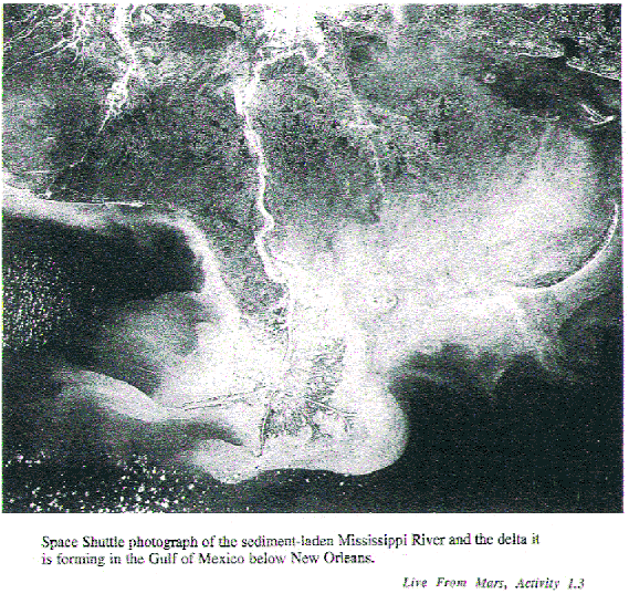
Water is essential to life on Earth: its abundant presence on our world drives the weather and shapes the land by rain, runoff and erosion. Whenever we see what looks like evidence of liquid water elsewhere in the Universe, we become especially interested, since water is a requisite for life.
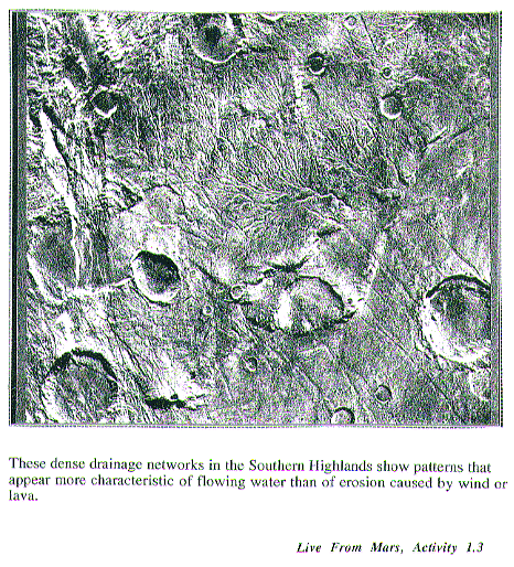
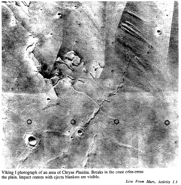
In the late 19th Century astronomers peered at Mars through telescopes and saw lines stretching across its surface: Giovanni Schiaparelli, an Italian, called them "canali" meaning "channels" or "grooves", which was translated into English as "canals." Some interpreted these "canals"as evidence of intelligent life, and even an advanced Martian civilization capable of massive, planet-wide engineering projects. Now spacecraft have looked close-up at Mars, and we know there are no canals built by a Martian Corps of Engineers. But some of the channels do have shapes which look much like those we see on Earth. While it's tempting to think of them as dried-up river beds, most scientists think many of the channels resulted from sudden releases of underground water or sudden melting of underground ice, rather than from sustained rainfall and enduring rivers. How do we know we're not fooling ourselves, or misinterpreting the data, as did some of those 19th century observers?
Scientists use different methods to understand the conditions under which the channels may have been formed. One method involves the use of stream tables, to simulate different rates of flow, from gentle rivers flowing for a long time, to sudden, massive floods. In this Activity, students will have the chance to discover for themselves some of the characteristic shapes created by differing volumes of water, flowing at different rates ("volume over time"). With "educated eyes"they can then turn to study images of Mars and recognize the features and discuss the mechanisms which might have caused them.
|
Objectives
Materials: for each team of students Please note: if these materials are difficult to secure, consider using only one set for the entire class, and assigning a different Planetary Geologist team per angle, and emphasizing the Image Processing and Data Analysis process for those who must watch. Although there will be less student hands-on time, it might be better to do the Activity in this way rather than foregoing it altogether, so important is the issue of water to Martian science and mission planning. |
Vocabulary
avalanche |
|
|
(Note: The Live From Mars videos will feature such images. More may be found in the slide set and the Explorer's Guide to Mars poster, included in the LFM Teacher's Kit.) |
|
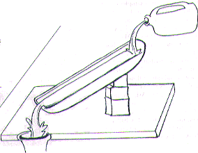
Engage Show students pictures or video of rivers and floods on Earth (perhaps local occurrences in your region). Do they think such conditions could exist on Mars today? Ask if they think Mars could ever have had liquid water. Or consider the question of water on Mars through a discussion on the possibility of life on Mars today in contrast to the distant past. Discuss conditions that seem necessary for life to develop. Cite the August 1996 announcement of the possible discovery of ancient Martian life in a meteorite. Explore / Explain Procedure Please note: some details are provided on the Student Work Sheet and its diagram, which you should review along with this procedure. 1. Distribute materials to each student team. Explain that each team is going to work as Planetary Geologists to investigate what can happen to a surface when water flows across it, and that they will share their data to come up with some principles by which water shapes landforms in specific ways. 2. Demonstrate stream table set up and use of the protractor to align the stream table at a given angle. This table should initially be set at an angle of 5 degrees.
Pour 1 quart of water into the 1/4 inch funnel and allow the water
to run down the tray through the groove as the teams watch. Have students
describe and sketch the flow pattern which results, carefully noting such
things as the shape of the flow pattern including 3. Assign each team a slant angle (from 5 to 25 degrees) and allow time for basic set up. For the first set of trials, each team should use the plastic funnel with the 1/4 in. opening. Teams should complete Trial # 1 and record results on the Student Worksheet. |
Teacher Background Students will see that at angles of about 15 degrees and higher, the sand will wash out. Larger volumes of water over shorter time periods (e.g. flood conditions) carve deeper channels with steeper sides. Only at angles of around 5 degrees, simulating gentler processes (e.g. slower flow over longer times) does the water begin to create curves and meanders more typical of terrestrial rivers. Remind students that most stream beds have slopes that are typically 5 degrees or less but that in this simulation the angle stands for flow rate, not the underlying topography of the planet. Also note that, as in most simulations, you can't replicate all aspects of the original condition you're trying to understand: for example, results obtained by using sand do not perfectly model rivers running through soil or over rock. But varying the angle does simulate flow rate, one key variable scientists think important for Mars. |
|
4. Before continuing, allow time for teams to contrast and compare
results from the stream tables set at different angles. Discuss. 5. Smooth the damp sand back to a uniform layer. Then repeat the same experiment at the same tray angle, but this time using the funnel with the 1/2 inch opening. Repeat Steps 3-4. 6. Again, smooth the sand. Repeat the experiments, but this time tell students to place the stones and the small bottle lids in the tray in such a position that the stream of water will encounter them, working them into the sand and adding a thin layer on top. (This simulates what happens when flowing water meets the elevated rim of an impact crater.) Have students carefully observe and record the appearance of the patterns in the vicinity of the bottle caps and stones at the end of the experiments. 7. Challenge students to answer the following questions: 8. As a last activity, simulate a large scale catastrophic flood by filling the gallon jug with water and carefully creating a uniform "waterfall" along the top of the stream table. Have students try with and without the stones and bottle lids in the flow. Again record and discuss results. 9. Finally, refer to Viking images of Mars. Ask students to look carefully at each one and challenge them to compare examples of the different types of patterns they created in their stream table experiments with what they see in the actual images of Mars. Ask them to draw conclusions about the presence of water on Mars in the past and to draw general conclusions about the differing amount and rate of flow of water in the various areas on Mars seen in the images. Ask them to search for signs of liquid water on Mars in the Viking images (i.e., on Mars today). Challenge them to hypothesize where they think all the water went.
| 
Expand/Adapt/Connect Research the various theories as to how water was released onto the Martian landscape at various times in the past and where scientists think it is today. Have students examine a map showing the geological surface features over the entire surface of Mars. Have them mark the location of outflow channels. Have them do the same with the location of valley networks. Ask them to describe the differences in their geographical distribution and challenge them to explain the reasons for this. Provide students with the prime landing site for Pathfinder as well as the coordinates of the Viking 1 and 2 landing sites. Ask students to describe these locations relative to the location of outflow channels and valley networks. Challenge them to hypothesize why scientists chose these particular locations to put spacecraft down on the surface of Mars. Research meandering streams. What is an oxbow lake and how is it formed? Why does a river bed change over time? Compare and contrast each terrestrial feature to landforms on Mars.
Write a news article about the stream bed simulations and report on your data.
Note: this Activity and Activity 2.2 are adapted in part from materials and concepts developed during workshops held by JPL's Mars Exploration Directorate as part of its Education and Outreach Initiative (Meredith Olson, Project Educator.) Related Activities may be found in the series of Student and Teacher Publications created by JPL: to order, contact TERC at 617-547-0430. The first two JPL-TERC modules and a set of Mars and Earth images are part of the LFM Teacher's Kit. LFM thanks Dr. Olson for her review of the adaptations of the original activities.
Suggested URLs |

![]()