You can measure the height or depth of a feature using the length of its shadow and a little trigonometry. If a crater rim or valley wall casts a clear shadow, the height of that valley wall or the depth of the crater can be estimated by measuring the s hadow length and using simple trigonometry.
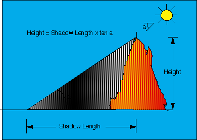
The formula for determining the height or depth y of a landform from cast shadows is
y = x tan (90 - INA)
where x is the length (horizontal distance) of the cast shadow.
(90-INA) is equal to the sun's elevation angle. The INA angle is measured at the center of the image and can be found in the image header.
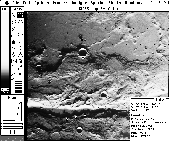
In the example image below, depths at several points have already been computed. The image has been reduced to 41% of its size for display purposes. A full resolution version is located in the VOImages folder. To try these measurements yourself, open t
he file 430S34 using FILE - Acquire -PDS. Next select PROCESS - Rank Filters - Median Filter (reduce noise). The reseau marks (the grid of black dots across the image) will still be present but other "noise" in the image will
be removed. Since this is a "raw" image, you can either adjust contrast and brightness levels manually by using the sliders in the Map window or select PROCESS - Equalize.
The next step is to set the scale of the image and measure the length of the shadow. Refer to the section on Measuring distances and areas in the tutorial for details on setting the scale and measuring distances. The scale of this image is 0.068 km/px. Be sure to measure across the length of the shadow from the landform to its corresponding spot on the terminus of the shadow. The shadow lengths at points A through E have already been calculated. Compare your answers with t hese and then try other areas on the image.
Now you need the sun's elevation angle. For this image, the INA is 81.33 degrees so the elevation angle (90 - INA) is 8.67 degrees. Now you can use the formula given above to find the depth of the valley and craters in the image. Compare your answers with those in the table.
| Area | INA (degrees) | 90 - INA (degrees) | Shadow Length (km) | Depth (km) |
|---|---|---|---|---|
| A | 81.33 | 8.67 | 3.67 | 0.6 |
| B | " " | " " | 1.43 | 0.2 |
| C | " " | " " | 2.92 | 0.5 |
| D | " " | " " | 2.38 | 0.4 |
| E | " " | " " | 2.17 | 0.3 |
Possible Problems or sources of error with measuring shadow length from Viking images:
1. You may be measuring a shadow length for a feature that is far from the center of the picture, where there is a significantly different sun angle.
![]()