T H U N D E R S T O R M S


1) WHY does a single cell thunderstorm form?

2) WHY does a multicell thunderstorm form?

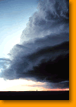
3) WHY does a supercell form?


1) WHY does a single cell thunderstorm form?

1) Warm, wet air rises from the ground. At higher altitudes, air pressure is less, the bubble of warm air expands and cools, and its water vapor condenses to form clouds.

2) At the top of the growing thundercloud, the drops of water become large enough to begin to fall down through the rising column of air, and create a downdraft, bringing rain to the ground.

3) Sometimes when the updraft is strong enough, pellets of ice form and keep on growing larger and larger. When they're 5-10 mm across they're heavy enough to fall as "hail": hailstones as large as 140 mm have been reported!

4) In a thunderstorm, updrafts and downdrafts exist side by side, resulting in violent weather, and producing the conditions which give birth to both thunder and lightning.

Back to Top


2) Why does a multicell thunderstorm form?

1) A multicell storm begins with a single cell thunderstorm (link to previous animation?) The downdraft from the first cell pushes a mass of nearby warm, wet air upward, triggering the growth of a second cell.

2) Cell 2 grows bigger, with its up and downdrafts creating violent weather. While Cell 1 and its rain, wind and lighting dies away, Cell 2 triggers Cell 3, sometimes making observers on the ground think a single cell has stalled over them, when in fact they're experiencing a succession of storms. This is what's called a "multi-cell cluster storm."

Back to Top


3) Why does a supercell form?

1) A supercell begins when fast upper atmosphere winds blow across slower winds close to Earth's surface, creating a rotating motion. When this rolling mass of air gets lifted up it forms a "mesocyclone."

2) The mesocyclone pushes some of the cool downdraft off in front of the storm, creating its own mini-cold front, called a "gust front", which acts like a snowplow pushing warm air up.

3) As the process repeats and repeats, some of the downdraft gets spun by the rotation of the mesocyclone into tornadoes. Supercells can last for several hours, traveling hundreds of miles, and bringing heavy rain, large hail, high winds and violent tornadoes.

Back to Top

Photographs provided by NOAA Photo Library