 |
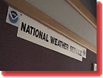
The National Weather Service Office, Norman, OK-under a typically stormy Oklahoma sky. It's one of the most modern in the nation, but what happens here is repeated all across America. | |
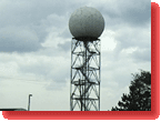 |
Here's where Doppler radar was developed and tested, and this is still where NWS forecasters are trained in the use of "WSR-88D." And when the sophisticated radars need fixing, it's folks from here who fly off to do the job. | |
|
There
are some 119 NWS offices all across America, but many of the innovations
in the recently completed modernization program began right here
in Norman.
|
|
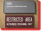 |
Let's go inside what's called the "Forecast Operations Area," and see how a modern NWS office operates, and who works here. "Restricted"? Don't worry, you're with P2K, so you're invited in! | |
 |
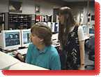
There are more computers and more monitors than people in this room. Just about every staffer seems to have 3 or 4 screens to check and double-check. | |
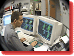 |
This student-intern from the University of Oklahoma may be one of tomorrow's meteorologists, but today he's got his eye on radar images of some severe storms brewing in the region. | |
 |
At the other end of the room sit the Warning Forecasters on duty. Their job is to issue Watches and Warnings if dangerous weather approaches. (See the JOURNALS from Doug Speheger and Geoff Haines-Stiles for stories of what it's like here when tornadoes touch down nearby.) | |
 |
About 6 people work here on a regular shift, with more brought in when storms are imminent. They function as a team: each checking out a different aspect of what's going on, and reporting back to the lead forecaster. | |
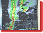 |
This is what a Doppler radar image looks like, with the red indicating areas of the most intense precipitation and wind. | |
 |
There are some real windows to the outside world of local weather, but whether it's day or night, these skilled forecasters mostly look through the electronic windows of their computers. | |
 |
Another window is the TV-tuned to the Weather Channel every day and to local stations when thunderstorms and tornadoes threaten. For the NWS, local TV chase crews are another very welcome set of eyes on the ground. | |
 |
A network of "spotters"-local emergency workers, police and firemen, and amateur weather enthusiasts-link in via ham radio: more eyes to help the NWS know what's really going on. | |
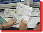 |
Each spotter calls in their position, and the forecasters check the latest data against maps of city neighborhoods and rural areas. Then they check it out against what the radar's telling them, and take action. | |
 |
When conditions get dangerous, it's time to put out an alert via NOAA's Weather Radio-the nation's only official voice of severe storms, and the most trusted source of emergency information. | |
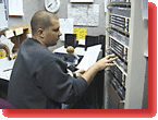 |
Today Joey's on duty: here at 19:55 hours, he's sending out notice of severe thunderstorms likely to produce tornadoes. |
|
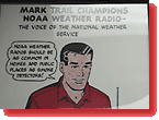 |
All across the nation, farmers, contractors, golf course operators, hikers and regular citizens now make Weather Radio the station to listen to when you need to know what's really going on. |
|
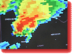 |
Today's one of those days. This Doppler radar image shows a red, hook shape-sometimes an indicator that intense winds are beginning to rotate in a pattern that may result in a tornado. | |
 |
They've got a certain number of pre-set weather warnings programmed in and ready to go-but today it's the human forecasters who have to make the call about what's going to happen in the coming minutes. | |
 |
It's a tense time, but it's what these NWS meteorologists have trained for. Their Watches get people ready to take action, and their Warnings are the trigger to move-out of the path of the storm, or down into shelters, away from a tornado. | |
 |
Some of the forecasters have the task of contacting local emergency managers: they make calls to office phones, homes, pagers-whatever it takes to get the word out to those who may have to evacuate their communities, or prepare emergency services. | |
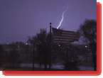 |
Outside in the dark and stormy night, the nation's flag cracks in the rain-and lightning strikes flash all around. | |
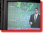
| Now local TV has pre-empted regular programming. The broadcast weathermen pass along the NWS Warnings. At times like these just about the whole community has got its eyes, and ears, and collective brain-power focused on the storm. | ||
 |
Now things are running like air traffic control: a new storm approaches, the forecasters check it out, issue their Watches or Warnings, make sure the word gets out, and then turn their attention to the next "incoming" salvo fired by Mother Nature. | |
 |
All hands are on deck: the early shift stays late into the night. The folks who launch balloons twice daily now staff the phones, fielding calls from the public, and making calls to check on hail and wind. | |
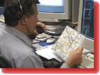 |
For the NWS forecasters at a time like this, all weather is local: the air crackles with reports of storms passing this or that highway, helping predict just which communities to alert farther down the track. | |
 |
So now, next time you hear "The National Weather Service has issued...", you'll know what it looks like behind the scenes as dedicated men and women, modern computers and a whole community of weather watchers all work together to collect the latest data, to keep you and your families safe in the middle of severe storms. | |