 |
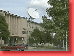
Suitland, MD, on the outskirts of Washington. "Mission Control" for NOAA's network of GOES satellites and ground support facilities. | |
|
"GOES"
stands for "Geostationary Operational Environmental Satellites."
They are the nation's eyes in "geosynchronous" orbit some 23,000
miles/35,800 kms above Earth. "Geosync" means they always keep station
above the same point on Earth.
|
|
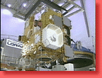 |
Seen here in a clean room before launch, they carry cameras which bring us the cloud patterns seen on local newscasts and, just as important, instruments producing "soundings" of Earth's atmosphere, revealing information about temperature, moisture, the oceans and ozone. | |
 |
At any one time there are 2 satellites in orbit, covering the East and West coasts. GOES 8 is at 75 degrees West longitude (looking down on the East Coast and the Atlantic) and GOES 10 is at 135 degrees West, (covering the Pacific and Hawaii.) A 3rd satellite, GOES 11, is also in orbit, providing a spare in case anything goes wrong! | |
 |
Each GOES has a camera which takes pictures in optical light: mapped onto a grid of the continent, you can track clouds, winds, and water vapor. As NWS Director Jack Kelly says, GOES satellites help us see both "the big picture and small-scale storm features." | |
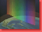 |
But there's a lot more going on than can be seen with the unaided human eye. That's why GOES and other satellites also carry instruments that "see" at other wavelengths of light. | |
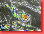 |
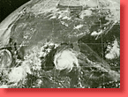
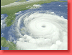
Each GOES carries infrared sensors which are especially important in detecting the heat signatures of hurricanes—like Hurricane Andrew pictured here—and tornadoes. GOES and other advances have helped the NWS improve forecasts times for severe weather of all kinds, resulting in an average lead time of 50.6 minutes for flash floods, a vast improvement over just 10 years ago! | |
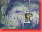 |
NOAA's GOES data, processed here by NASA's Goddard Space Flight Center—which handles the launch and initial deployment of the satellites under contract from NOAA—reveals the internal structure of hurricanes in images of astonishing beauty as well as great scientific significance. | |
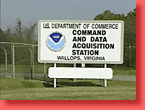 |
Signals from both GOES satellites are beamed down to NOAA's Command and Data Acquisition Station at Wallops, VA. The ground station passes the data on to Suitland, and then beams back processed information to users like the NWS, again via GOES. GOES also relays messages from data buoys across the ocean, free-floating weather and research balloons, and even emergency "SARSAT" calls, ("Search And Rescue Satellite Aided Tracking.") These are very hardworking satellites! | |
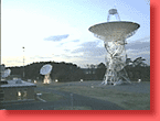 |
From Wallops the data is transmitted to Suitland, the Satellite Operations Control Center or SOCC, where the spacecrafts' health is monitored, and new commands, if any, are checked out before being uplinked to the satellites. | |
 |
The SOCC building is busy 24/7. In addition to the GOES satellites, NOAA also operates two Polar Operating Environmental Satellites—as you would expect, they're called "POES"! They're used to monitor longer-term climate as well as severe weather. In addition NOAA has taken over operation of the Defense Department's Meteorological Satellite program. Just like the satellites, this control room is ever-active. | |
 |
NESDIS staffers check out the normal operation of the spacecraft. The better the forecasts made with the help of GOES, the more important it is that there's no break in operation—one more reason NOAA likes to have a spare, in place, on orbit. | |
 |
In addition to clouds, rain, hurricanes and tornadoes, GOES data also helps provide warnings of tsunamis and cyclones, floods and snow depth, and works with 3 other similar satellites, operated by other nations, to provide unprecedented global coverage of our ever-changing world. |
|
 |
Around the nation, NOAA staffers transform GOES and a steady stream of data from balloons, ground stations and other satellites into useful forecasts, working with new software that integrates radar, infrared and other kinds of information into immediately comprehensible information, all on one screen. They call this "AWIPS"—but we've used up our share of acronyms for this Site Tour! | |
 |
GOES, operated by NOAA with support from NASA, has revolutionized weather forecasting. Just a few decades ago, researchers had to visualize hurricanes with black and white X and O's on computer printouts. Now, thanks to GOES, we've a new view of our planet, and the weather and climate that impacts our daily lives. | |