|
It
all started pretty low-key. "We launch the second daily weather balloon
at 5:00 p.m.," said Dennis McCarthy, meteorologist in charge of the
National Weather Service Forecast Office in Norman, OK. "Great," I reply,
"can I hang out and see what happens?" "Sure," says Dennis. He's a pretty
low-key guy himself, bearded like a sea captain of old, mid 40's-early
50's.
 But
when you listen to the researchers, emergency managers and tv weathercasters
who lived through last May 3rd's deadly tornadoes that blasted Oklahoma
City and its surrounding communities, leaving 45 dead, you realize there's
a lot more beneath that calm exterior. Many credit Dennis and his team,
along with the new tools the NWS has rolled out around the nation, with
helping minimize casualties. There were 67 tornadoes that day, 50 "weak"
and 17 significant, with one F-5, (named for researcher Ted Fujita),
the deadliest kind of tornado any of us can expect to experience, with
the highest winds and greatest destructive power. It was the first F-5
since 1982, and the first-ever to hit OKC, a densely populated area.
Recent studies released at the American Meteorological Society's annual
meeting reported that without the combination of NWS forecasts and community
mobilization--in which local TV stations and radio were key--there might
have been more than 600 deaths. As it was, there were 1,000 injuries,
11,000 homes destroyed, 300 businesses lost, and $1.5 billion in insured
losses. But
when you listen to the researchers, emergency managers and tv weathercasters
who lived through last May 3rd's deadly tornadoes that blasted Oklahoma
City and its surrounding communities, leaving 45 dead, you realize there's
a lot more beneath that calm exterior. Many credit Dennis and his team,
along with the new tools the NWS has rolled out around the nation, with
helping minimize casualties. There were 67 tornadoes that day, 50 "weak"
and 17 significant, with one F-5, (named for researcher Ted Fujita),
the deadliest kind of tornado any of us can expect to experience, with
the highest winds and greatest destructive power. It was the first F-5
since 1982, and the first-ever to hit OKC, a densely populated area.
Recent studies released at the American Meteorological Society's annual
meeting reported that without the combination of NWS forecasts and community
mobilization--in which local TV stations and radio were key--there might
have been more than 600 deaths. As it was, there were 1,000 injuries,
11,000 homes destroyed, 300 businesses lost, and $1.5 billion in insured
losses.
 Images
of the May 3rd event, with one aerial image from the "Daily Oklahoman"
looking literally as if a malevolent vacuum cleaner had just sucked
houses from the ground, are all around Forecast Office. Together with
images from killer tornadoes of the past, these powerful pictures stop
you from thinking about the cluster of modern computer work stations,
and the men and women who operate them, as just one more high-tech company,
crunching numbers and studying images: these folks deal with life and
death. Their business is turning weather science into public safety.
Dennis had been on duty that night too, as had Doug Speheger, who was
to take the lead as warning forecaster this December 2nd. That night
I got to see, from the inside, something of what it must have been like
last May 3rd: this time there were, thank heavens, no fatalities, but
there was enough adrenalin flowing to see NOAA's systems and, perhaps
more importantly, its people in action. Images
of the May 3rd event, with one aerial image from the "Daily Oklahoman"
looking literally as if a malevolent vacuum cleaner had just sucked
houses from the ground, are all around Forecast Office. Together with
images from killer tornadoes of the past, these powerful pictures stop
you from thinking about the cluster of modern computer work stations,
and the men and women who operate them, as just one more high-tech company,
crunching numbers and studying images: these folks deal with life and
death. Their business is turning weather science into public safety.
Dennis had been on duty that night too, as had Doug Speheger, who was
to take the lead as warning forecaster this December 2nd. That night
I got to see, from the inside, something of what it must have been like
last May 3rd: this time there were, thank heavens, no fatalities, but
there was enough adrenalin flowing to see NOAA's systems and, perhaps
more importantly, its people in action.
 It
has been a typical Oklahoma day: perhaps a little bit more moisture
from the Gulf than usual to make it humid. Winds from the west were
pushing the so-called "dryline" east. Late day clouds had grown dark
and cauliflower like. Given the farmers and ranchers in the region,
the forecasters were quite looking forward to some rain. It had been
unseasonably dry. No-one, early in the afternoon, expected quite what
they got that evening. But, after last May 3rd, they were ready by 17:00
hours. It
has been a typical Oklahoma day: perhaps a little bit more moisture
from the Gulf than usual to make it humid. Winds from the west were
pushing the so-called "dryline" east. Late day clouds had grown dark
and cauliflower like. Given the farmers and ranchers in the region,
the forecasters were quite looking forward to some rain. It had been
unseasonably dry. No-one, early in the afternoon, expected quite what
they got that evening. But, after last May 3rd, they were ready by 17:00
hours.
 |
|
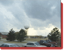
Storm
clouds over an
experimental doppler radome
|
The
weather balloon got filled--with inexpensive but volatile hydrogen,
saving money said the techs.--and launched. Blown sideways by what had
become gusty winds, it accelerated up, 1,000 meters in 2 minutes. (Similar
launches at noon and midnight GMT happen around the world, and working
with the World Meteorological Organization, we hope to show you how
the whole world watches weather during LIVE FROM THE STORM.)
|