Inside
a Tornado
Dr. Kevin Kloesel - 05/27/99 - 02:23:32
Distance
Education Director / NOAA Liaison
Oklahoma Climatological Survey, Norman, OK
|
|
Inside
a Tornado |
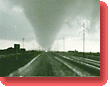
Don't look at the time on this message! It got too good to leave! HaHaHa! We just crashed at a Holiday Inn in Odessa: now if the adrenaline would just wear off! We had some chase tonight... yesterday was cool, we did 704 miles, and the stories would have been cool--at least until today. Today was unbelievable... 450 miles...which culminated in a 300 meter tornado genesis intercept...
Our only escape route was to head southwest (we were due east of the mesocyclone, but directly in the path of the hail core which had grapefruit size hail in it) so Josh decided we could outrun the storm to the SW (rather than let the meso slide to our SW and us be destroyed by hail.) We almost beat it, but we got to the same point at the same time. What a ride! Check out the Weather Channel video, they were in the car behind me and had windshield damage and a vehicle with more dents than a golf ball. Their crew just uploaded the video to Atlanta... they will probably show some tomorrow. I've NEVER seen anything like it... horizontal wind driven hail in a mesocyclone!!! Can you tell I could do this for a while??? I am driving DOW 3 back tomorrow...(Oh, DOW 2 didn't survive the first day... :) ) Kev
Ed. note: We first read this exciting diary of a day spent chasing tornadoes when it was sent to us by a member of the LFSTORM materials development team, via the FLORIDA EXPLORES remote sensing educational project. If you come across any interesting and informative stories of what it's like on the frontlines of weather and climate research, please share them with us by sending e-mail to: ptkinfo@passporttoknowledge.com |
| Non-Flash Journal Index | Inside a Tornado 1 |
![]()

 Ever
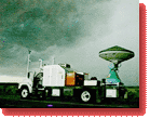
been directly beneath a mesocyclone? Twice in one evening? The latter
in pitch black? We had 1,200 lightning strokes in 10 minutes so we could
see everything in 'strobe effect'! Anyway, we dented the DOW (ed: Doppler
On Wheels--the mobile radars on small trucks used to get close-up, highly
revealing radar images of what the winds inside a hurricane are doing)
big time, cracked the industrial strength anemometer and lost some windshields
of the 'ducklings' (the chase escort cars--they follow the DOW and stay
out of my way when I want gasoline!)
Ever
been directly beneath a mesocyclone? Twice in one evening? The latter
in pitch black? We had 1,200 lightning strokes in 10 minutes so we could
see everything in 'strobe effect'! Anyway, we dented the DOW (ed: Doppler
On Wheels--the mobile radars on small trucks used to get close-up, highly
revealing radar images of what the winds inside a hurricane are doing)
big time, cracked the industrial strength anemometer and lost some windshields
of the 'ducklings' (the chase escort cars--they follow the DOW and stay
out of my way when I want gasoline!)
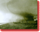
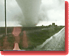 Pitch
black, lightning everywhere, baseball sized hail, being driven into the
right side of the vehicle by 60+ winds...in a multi-ton truck with $300,000
worth of equipment, and Josh (Oklahoma University researcher Josh Wurman)
in the back calmly saying "we're right under the hook, keep up your speed
and we'll live." 30 seconds later (it seemed longer!) we were on the southwest
side as it dropped a tornado just east of our location. We were in a 'run
away' mode on roads that are tough to chase on. Unfortunately, the storm
surged southeast on us, cranking its forward speed to 40 (from 30 as we
had tracked for the previous hour).
Pitch
black, lightning everywhere, baseball sized hail, being driven into the
right side of the vehicle by 60+ winds...in a multi-ton truck with $300,000
worth of equipment, and Josh (Oklahoma University researcher Josh Wurman)
in the back calmly saying "we're right under the hook, keep up your speed
and we'll live." 30 seconds later (it seemed longer!) we were on the southwest
side as it dropped a tornado just east of our location. We were in a 'run
away' mode on roads that are tough to chase on. Unfortunately, the storm
surged southeast on us, cranking its forward speed to 40 (from 30 as we
had tracked for the previous hour).