S N O
W A N D I T S D
E F I N I T I O N S
 All
forms of precipitation can be traced back to very cold conditions inside clouds,
and all of the 10 kinds of winter precipitation described by the international
snow classification system begin as snow.
All
forms of precipitation can be traced back to very cold conditions inside clouds,
and all of the 10 kinds of winter precipitation described by the international
snow classification system begin as snow.
Snow
is created when the temperature of a cloud is low enough (about 28 degrees F.)
to allow the formation of crystals. It all begins with a tiny drop of water
that gets bigger and bigger as water vapor condenses onto it. Eventually, the
droplet gets so cold it freezes into a microscopic ice crystal. At about 5 degrees,
the crystal develops the familiar hexagonal shape of 6 branched arms we identify
with snowflakes, the shape kids in elementary school make out of cut paper and
that you see on greeting cards. Initially these ice crystals are too tiny to
see, but as they circulate in the cloud, they bump into more water vapor which
condenses onto the crystal, enlarging it. Eventually, an accumulation of crystals
will become too heavy to remain in the cloud and so it falls to the ground.
When the air just below the cloud is cold enough that the crystals don't melt
(about 30 or 31), they will reach the surface of the earth as snowflakes. When
the ground is warm and the snow that touches it melts, the melting snow cools
the earth and makes it possible for more falling snow to accumulate. (Make your
own Winter Weather and see what mix of warm and cold air creates snow and freezing
rain in the Interactive Animations,
in the WHY section of the website.)
Snow
fall can be described in a number of ways, based on the amount, interval, and
intensity at which it drops from a cloud to the Earth: "Flurries" are the least
worrisome type of snowfall: in a flurry, a very small amount of snow falls for
a short while, and little to no snow accumulates on the ground.
- "Showers"
are the second kind of snow: in the case of a shower there may be a bit of
accumulation that results from more intense snowfall over a brief period.
- "Squalls"
are brief (usually about a half an hour or less), intense showers accompanied
by strong, gusting winds.

- "Blowing"
snow can be either falling snow that is driven by strong winds or fallen
snow that is picked up and tossed around by winds; this type of snow can seriously
impair visibility and causes drifting.
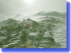
- A "blizzard"
is a combination of falling and/or blowing snow with sustained winds or frequent
gusts of at least 35 mph; in a blizzard, visibility is a quarter of a mile
at best for a three-hour period or more, and temperatures are usually 32 degrees
or below. In Antarctica, blowing snow creates blizzard conditions: although
the continent gets only a few inches of snow a year, the temperatures are
so cold that the snow doesn't melt, and instead remains to be picked up by
the fierce winds (the strongest on Earth) and blown about.
When snow accumulates, it weighs heavily on telephone wires,
electrical poles, trees branches, roofs, and whatever else it happens to land
on. In addition, heavy snow can cause avalanches in mountainous areas--in
fact, 90 percent of reported avalanches happen during or immediately following
a snowstorm. Avalanches occur when a new layer of snow slides off an older,
underlying layer. They can be caused by movement on the surface of new snow,
or by freezing and thawing temperatures which can detach layers. When warm
temperatures are followed by a storm, snow falling at rates of one inch or
more per hour creates a slippery layer which can easily slide off the melting
snow beneath.
- "Sleet"
is formed when snow falling from a cloud hits warmer air just beneath the
cloud and melts, only to refreeze when it encounters more cold air later in
its downward journey. When the melted snow--rain, essentially--hits this freezing
air, it turns into ice pellets that bounce when they hit the ground and do
not stick, but accumulate much like snow.
- "Freezing
rain" falls when snow melts after dropping from a cloud and encountering
warmer air. Although the rain super-cools on its way down, it doesn't become
ice until it touches the ground or whatever else is in its way. When this
cold rain falls on a frozen surface, it freezes into a solid coat or glaze
of ice. In an ice storm, freezing rain can weigh on and eventually pull down
trees, utility poles and communication towers, in addition to posing a huge
hazard to anyone driving or walking on the ice.
- "Graupel"
is another form of falling ice, a small, soft hail that is formed when ice
crystal fall through super-cooled water drops. The water drops freeze onto
the crystal when they touch it, often obscuring the crystal's hexagonal shape.
Very small super-cooled drops freeze instantly upon contact with a frozen
surface. Because individual drops freeze so quickly, air is trapped between
the ice balls. The trapped air gives the ice, called rime, an opaque,
whitish color. Larger super-cooled drops spread out over a surface before
they freeze, creating a smooth, slick surface called a glaze.
- "Glaze"
is slippery, "rime" is not. Rain is snow that melts on its way down
from a cloud and never re-freezes because it remains in warm air.
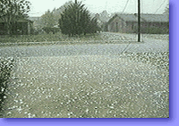
- "Hail"
primarily, but not entirely a summer and springtime phenomenon can happen
whenever there are thunderstorms. Most of the more than 91,000 hailstorms
recorded since 1955 hit in May and June. Hailstones are formed when ice crystals
in a thundercloud are tossed and bounced around by the storm cloud's updraft,
and they bump into water vapor, which condenses onto the crystal until the
crystal has developed many coatings of ice. The resultant hailstones are so
big that by the time they drop down to earth that don't melt away even though
they are falling through warmer air. The largest hailstone on record was found
in Kansas in 1970: it was measured at more than 7 inches wide and weighed
1.7 pounds.
