| S p e c t r a l I n f o r m a t i o n
One way to use aerial images is through a "pixel by pixel" classification process. Pixels of similar spectral information (which we can simplify as meaning "color") are grouped together into different classes (or colors) representing different tree species. The example below shows what's called the "maximum likelihood classification technique" applied to an aerial image of the tropical rainforest. |
|
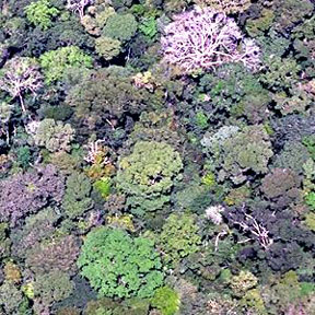
| Fine spatial resolution imagery of tropical tree canopy: |
|
| Image enhancement can improve understanding of the exact content of the image: |
|
| A "classified" (or sorted) image, showing biodiversity of trees within the image: |


| Remote Sensing: Seeing the Forest and the Trees Spatial Resolution Spectral Information Morphometric Information Tree Phenology Jungle Tower |
![]()