
Live From Mars was active July 1996-December 1997.
Optional Activity
The purpose of this exercise is for students to accurately chart the position of the planet Mars across the sky by repeated measurements over a period of several months. The students will have to construct a rudimentary instrument to measure the angular distance between Mars and at least two bright, nearby stars.
Materials and tools:
One wooden yardstick - these are usually available at paint or hardware stores.
(Meter sticks will work just as well - I bought one at a True Value store
for 53 cents.)
A plastic protractor (or make your own - just need 90 degrees)
A thread 12" long
A small weight (a couple of washers)
Adhesives (5-minute epoxy probably best)
Small nails or screws (tools to pound nails or drive screws)
A small saw to cut yardsticks to proper length
A couple of popsicle sticks or similar wood
Star chart or finder (can obtain from Website)
Graph paper, compass, and ruler for plotting the planet
A small flashlight (borrowed). Red cellophane to cover flashlight
A notebook and pencil to record your observations
If several instruments are constructed at once, costs should be quite moderate, certainly less than $5 per instrument. It would also be best if students worked as teams.
Construction:
Cut the yardstick into two pieces 30 and 60 cm in length.
Carefully glue and nail (screw/bolt) them together at a right angle into the shape of the letter "L." Make sure the numbers are visible. I'd prefer the "L" to be where the two pieces meet. Also attach the pieces at the flat part, not the edges.
Attach the protractor (actually, you only need 1/2 a protractor) to the middle of the short yardstick piece along the inside edge. Attach a thread to the center reference of the protractor.
Tie a small weight to the other end of the thread.
You might want to put small nails or pins at the outside corner of where the "L" comes together to aid in making observations. I also added a small slide made of popsicle sticks to act as a gauge along the long stick.
This is what the finished instrument should look like:
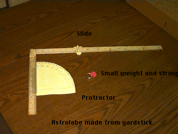
You will need to figure out how to mark and convert the measurements on the yardsticks into degrees. If you built it correctly, a 45-degree angle will occur when both sticks are equal in length (about 30 cm). You can use the measurements in cm off the stick, and then convert to angles. Or you may wish to mark the angles directly on the yardstick beforehand.
Making Observations:
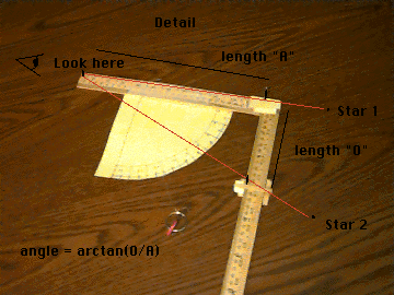
Objects in the sky are located by making two measurements. The stars are viewed as if they were at infinite distance on the surface of a celestial sphere. Earth is at the center of this sphere. If one were to project the position of the star from its posi tion to the center of the Earth, it would intersect the surface of the Earth at some position which would have a latitude and longitude. The equivalent of latitude is called declination, and is measured in degrees. The North Pole is a +90 degrees and the South Pole is given as -90 degrees. Declination is commonly written as +4546 or -3014. This would mean N 45 degrees, 46 minutes and S 30 degrees, 14 minutes. (There are 60 minutes to a degree. Since the Earth spins about its axis, every day it spins 360 degrees in 24 hours.) For various historical reasons the celestial equivalent for longitude is called Right Ascension and is given in hours, minutes and seconds. One hour of right ascension is equal to 15 degrees. Refer to this example for a detailed explanation of finding stars and their coordinate system.
It is relatively easy to determine declination (hence latitude). It is hard to measure right ascension without the aid of a very accurate time piece. (Actually most modern digital watches are probably good enough.)
Use your Astrolabe to determine the declination of Polaris, the North Star. To do this, first use a star chart to identify the "Big Dipper." Follow the line made by the two stars at the end of the Big Dipper's cup to locate Polaris. (Polaris is not a particularly bright star, and may be hard to find.) Site along your Astrolabe's long yardstick. Gravity should pull the string straight down along the protractor. Either hold the string or have a friend using the flashlight read the measurement.
Question 1. What was the measurement?
Question 2. Make the same measurement at several
different times during the night. Does the measurement change? Why or why
not?
Question 3. What is the latitude of your observation site?
Is this measurement similar to the one obtained by your Astrolabe?
Question 4. The declination of Polaris is about 89 D. What is the
relationship of the latitude of the observing site to the observed declination of Polaris? Why is this so?
Question 5. For each of these questions fill in the blank.
5a. You are at the North Pole. The observed declination of Polaris
is____.
5b. You are at the equator. The observed declination of Polaris is _____.
5c. You are at 45 degrees N. The observed declination of Polaris is
_____.
5d. You are at 30 degrees N. The observed declination of Polaris is
_____.
By measuring the shadow the Sun makes over the course of a day, one can learn about declination and latitude. If these observations are repeated once a week over the course of the semester, one may get some insight on seasons. This device is basically a fancy sundial, so you can use it for a clock as well as a latitude determination device.
You can use the declination gauge on the Astrolabe by using its shadow. If you turn your back to the Sun and line up the Astrolabe so it makes the smallest shadow possible (on a wall or any flat object - you might want someone to hold a light-colored piece of cardboard), you can read the declination of the Sun (or other bright object) directly off the gauge.
Try doing this several times during the day, and over the course of a year, noting the time of the observation.
(An alternative method - this could also be done using a pinhole in a window shade.)
Materials
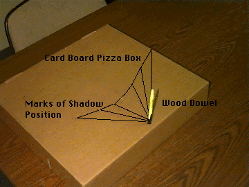
One flat cardboard box (big pizza box is perfect)
One straight stick or dowel - 8" (a pencil works fine)
Protractor (optional)
Pencil or other marker
Trig tables (calculator with trig functions - slide rule - or something like that)
Some duct tape (always handy - good for restraining unruly students)
A wrist watch
To make the observations you need to find a flat surface in a sunny spot (picnic table?). Tape the box to the table so it doesn't move. Put the stick in the south edge of the box. Make sure the stick is straight up and down. You want to arrange the stick and box, so that the end of the stick's shadow falls on the box. Measure the height of the stick above the box. Make your observations every 1/2 hour or 15 minutes by marking the position of the tip of the stick's shadow and the time the measurement was made. Also mark the position of the stick on the box and measure the length of the stick above the box.
I would try to measure from 10 A.M. to 2 P.M.
If all goes well, you should have plotted out an arc with the shortest shadow marked at about noon.
Questions
1. How tall is the stick?
2. How long is the shortest shadow?
3. When does the shortest shadow occur? If not exactly at noon, why not?
4. Using trigonometry (or making a model and using a protractor to measure
the angle), how high did the Sun get in the sky? What is this measurement
called?
5. How does the angle of the Sun in the sky relate to your latitude?
6. Would this angle change during the year?
7. How is latitude related to seasons?
8. If you were lost in the woods on a sunny day, how could you use what you learned today to help you find your way home?
9. What was Stone Henge?
10. If you live at the equator, when is the Sun directly overhead?
Note: You might want to repeat this exercise a few times during the year.
If you made the Astrolabe according to directions, you should be able to measure separations of at least 60 D (4 hours), however, separations over 45 D (3 hours) are difficult to measure.
Try your hand-eye coordination to measure the angular separation between some of the brighter stars in the table. Here are some to try:
In the Constellation Leo, the stars Denebola (1148 +1444) and Regulus (1007 +1208). The constellation Virgo's star Spica (1323 -1100) and Denebola. Castor and Pollux in the constellation Gemini, Betelgeuse and Bellatrix in Orion.
Use this star chart. Or use the following program to draw a custom star chart: NPH-CHART Program.
You may wish to 'plot' the positions of the stars using your measurements of declination and angular separation. To do this make or copy a piece of graph paper, or use a copy of the star chart generated below.
Using the chart of star positions you created in exercise 3 (see example), plot the position of Mars at least once a week from February to May.
Was there anything unusual about the motion?
How can you explain it?
To help you find Mars in the sky, you can use the following automatic star chart drawing program. It is set to draw the current position of Mars. Make sure you pick Mars as the planet, Leo as the constellation, limiting magnitude of 5, and stereoscopic projection.

![]()