
Live From Mars was active July 1996-December 1997.
Teacher Background
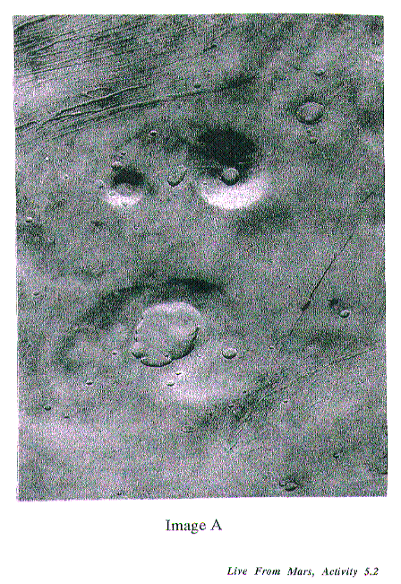
As we've seen, one of the most enduring beliefs about Mars is that it once was inhabited. Remember the 19th century mania about canals and the alluring fiction of H.G. Wells and Orson Welles? Since the Viking mission, some people think they can see new physical evidence of a past civilization on Mars: they interpret images of one particular area as showing a face--a kind of monumental structure rather like the Sphinx and Pyramids of ancient Egypt. Most scientists are very skeptical about this, and argue that the face is just a trick of the light playing on natural surface formations. Still public interest remains. This Activity uses the face as a way to dramatize the kind of image interpretation planetary geologists must do to account for illumination angles before they can determine surface structure. It also serves as an antidote to contemporary wishful-thinking which echoes Percival Lowell's now discredited beliefs. Armed with experience in image analysis, students (and their parents) can better make up their own minds about the face, the pyramids, the library and other fabulous monuments on Mars.
Objective
Materials: For each student or team of students
|
sharp shadows in a darkened room |
|
Vocabulary image angle ratio shadow elevation depression |
Procedure
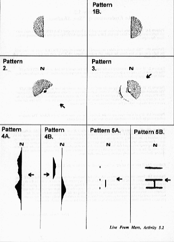
Tell students that they are on an Imaging Team whose task is to interpret the first images sent back to Earth from a planetary probe to an unknown world. Distribute copies of Shadow Pattern 1A to students. Explain that this is a simulated image from an orbiting spacecraft of a planetary surface feature and that the dark area is a shadow cast by the surface feature. Ask them to write down what they think is the actual shape of the feature. Tally answers on the board. Distribute copies of Shadow Pattern 1B. Again, pose the same question. Tally answers on the board. (If they seem to need a clue, tell them that the surface features are either a dome shaped mountain or a bowl shaped crater.) Allow time for discussion and re-evaluation of their original guesses. Then reveal to students that without an additional piece of information, there is no way they can conclusively state the answer.
Suggested URLs
http://barsoom.msss.com/education/facepage/face.html
http://barsoom.msss.com/education/happy_face/happy_face.html
Explore/Explain
Procedure
1. Explain to students that without knowing the direction of the incoming light they don't really know whether the surface feature in question is a mountain or a bowl shaped crater with no rim.
2. To illustrate, complete the following demonstration: Using two 3-D models (one of a mountain and one of a rimless bowl shaped crater) in a darkened room, hold the light source at nearly right angles to the surface of the clay (as would happen if the sun was low in the sky). First hold the light right and then left of each feature and refer to Shadow Patterns 1A and 1B as you do this. Show students that relative to the same incoming light, a shadow cast by the mountain differs from that cast by the crater. Explain that when scientists examine new images of planetary features from orbiting spacecraft, they must take the viewing angle of the spacecraft and the angle of the sun into account. If they don't, the images may be misinterpreted. Also note that the images from spacecraft are 2-D renderings of 3-dimensional objects and the way something looks often depends on the angle from which we are viewing it and the angle of incoming light.
3. Distribute Shadow Patterns 2 and 3, pieces of modeling clay and light sources to teams of students. Tell them that in each Shadow Pattern image the arrow indicates the direction of the incoming sunlight and the letter "N" indicates the direction North. For each pattern, challenge them to discover the direction the sun would appear in the sky if they were standing on the surface of the planet where the feature is located and the approximate shape of the surface feature. Have students model the surface features with their clay and reproduce the shadow patterns using their light sources. Have teams verify each others' models.
4. Once students have mastered the above, distribute Shadow Pattern 4A. Ask them to determine the direction of the sun in the sky if they were on the surface of the planet, and the nature and shape of the surface features casting these shadows. Write their hypotheses on the board and discuss.
|
5. Distribute copies of Shadow Pattern 4B. Explain that this is an image
of the same region on the planet but taken about 12 hours later. Ask
students to determine the direction of the sun if they were on the surface
when the image was taken. Tell them to examine this image and compare it
to the one taken 12 hours earlier. Each team should discuss what physical
feature(s) might be represented by the shadows in 4A and 4B, then
construct a model using light sources and clay. Teams can verify each
others' models. 6. Distribute copies of Shadow Pattern 5A and again ask teams to determine the direction of the sun in the sky and guess the shape and nature of the surface features casting the shadow. (Note: A variety of correct answers are possible based on only this one image.) After various possibilities are formulated and discussed, tell students that you have inside information that at the time this image was taken the sun was rather high in the eastern sky and the surface features in question are actually a series of straight and narrow trenches in the surface of the planet. Three of these trenches run East and West and are the same length. The fourth trench runs North and South and is about half the length of the others. Using this information, ask teams to model these trenches and shadow patterns using clay and light sources. Next, ask students what the shadow pattern created by these trenches would look like if the sun were lower in the planet's eastern sky when the image was taken. Have teams recreate this with light sources and clay. After teams have shared their models, reveal the correct answer (Shadow Pattern 5B). Explain that while this example was clearly contrived for the purpose of humor, the point made is a very important one: surface features can take on very different appearances depending on the direction and height of the incoming sunlight and that more than one image is often needed to accurately deduce the nature of a planetary surface feature. Without such help, the eye and brain can easily be deceived! |
The Face on Mars: Tools to Explore the Viking images MGS's camera was designed by Michael Malin, who is not only an ingenious researcher, but also a scientist of wide interests, ranging from Mars to Antarctica. (see biographical excerpt on p. 6) His company, Malin Space Science Systems, will be handling all the image processing for MGS and supporting public education and access. One of Malin's goals is to help people understand complex phenomena with the best of today's tools. His fascinating home pages provide ways to explore the Face on Mars for yourself: here a sampler of what you can find at: http://barsoom.msss.com/ education/facepage/face.html In July, 1976, Viking Orbiter 1 was acquiring images of the Cydonia region of Mars as part of the search for potential landing sites for Viking Lander 2. On 25 July, 1976, it photographed a region of buttes and mesas along the escarpment that separates heavily cratered highlands to the south from low lying, relatively crater-free, lowland plains to the north. Among the hills was one that, to the Viking investigators scrutinizing the images for likely landing sites, resembled a face ...Subsequent to this release, some people have argued, mostly in the lay literature, that the face-like hill is artificially shaped. Although their argument has been expanded to a host of nearby features, none commands public interest like the "Face." Malin's page will provide interested persons with both the raw Viking images, transformed to GIF format, and a brief tutorial (with examples) of image processing techniques applied to create "better looking" images. Not everybody agrees with Malin's interpretations. Here is another viewpoint. |
|
7. Distribute copies of Image A and B. Explain to students that these are
two actual images of Mars taken by the Viking orbiters. Explain that Image
B is an enlargement of a section of Image A, but taken at a different time
of day on Mars. Challenge students to draw a square inside Image A to show
the area covered by Image B. Then ask students to draw an arrow next to
Image A to indicate the direction of the incoming rays of the sun at the
time this picture was taken. Have them do the same for Image B. Verify
their results. Finally, have them create a model of the terrain shown in
Figure A. 8. Discuss how they would figure out the height or depth of the elevations or depressions. Students should realize that they do not have enough information for a definitive answer. They must also know the height of the sun above the horizon at the location of each surface feature and the length of the shadow to know how high or deep the surface features really are. Lead students to a realization of this important point by having them experiment with the length of shadows cast by a ruler. Have them stand a ruler on edge by sticking it in a piece of modeling clay and record the length of the shadow cast by the light when it is held directly over the ruler (at 90°--to the top of the desk or table top--at 60°, 45°, 30° and 10°). 9. Distribute the transparent grid overlays and have students return to Shadow Patterns 2, 3 and 4. Tell them the grids they have just received are a measuring scale for their spacecraft images. From the height of the spacecraft above the planetary surface, it has been determined that each square on the grid is exactly three square miles. For each Shadow Pattern, tell them the elevation angle of the sun above the horizon and ask them to calculate the approximate height or depth of the surface feature creating each shadow. 10. Finally, challenge students to use their modeling clay, their light sources and the class video camera to create shapes that cast different shadows and make the overall shape look different when the incoming light comes from varying angles and varying directions. Have teams of students secretly record their modeled shapes with the video camera and then challenge the other students to figure out the actual shape of the modeled clay by trying to duplicate the shape with a piece of clay themselves. Each team, as they challenge the rest of the students can offer clues (e.g. the direction and elevation angle of the incoming light). |
Expand/Adapt/Connect Younger students love shadow play. This entire exercise can be done qualitatively with them. They can be led to see that lower angles make longer shadows. They may also want to note the length of their own shadows vs. their own height as well as the direction of their own shadows in the playground at different times during the school day.
Download the image of the "Happy Face" on Mars. Is it also the work of an intelligent, optimistic, ancient Martian civilization?
|

![]()