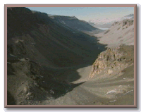
Rising high above the western shore of McMurdo Sound and the Ross Sea, 90 kilometers from Ross Island, the glacier-mantled peaks of the Transantarctic Mountains provide a beautiful background to the McMurdo area. Continually changing patterns of light and shadow through a 24-hour austral (southern) summer day bring out both the range's gently rounded glacial contours and the abrupt rock faces. The range is characterized by nearly horizontal layers of sedimentary rocks-mostly a yellowish sandstone (Beacon Sandstone of Devonian age) and interlayer of dark dolerite (a lava similar to basalt) that were injected as sills between the existing sandstone layers.
|
|
|
Several large valley glaciers flow from the polar plateau through gaps in the range, some joining the Ross Ice Shelf and some flowing directly into McMurdo Sound. Of greater interest, however, are several ice-free valleys that contrast with this land of seemingly perpetual and complete ice coverage. Known collectively as the McMurdo Dry Valleys, they are within helicopter range of McMurdo Station and have become the object of much scientific research.
From south to north, these include the Taylor, Wright, McKelvey, Balham, Victoria, and Barwick Valleys. The valleys have certain common characteristics, although some have unique features. Generally, they are 5 to 10 kilometers wide between the crests of intervening ridges and are 15 to 80 kilometers long. The valleys are ice-free because of the geography of their upper, or western ends, where high lips slow the entry of ice from the east Antarctic ice sheet.
|
|
WANT TO LEARN MORE?
|
|
Websites
• McMurdo Dry Valleys Long-Term Ecological Research (LTER) The homepage for the LTER project in the McMurdo Dry Valleys. • Virtual Tour - McMurdo Station, Antarctica A virtual tour of McMurdo Station including images of British explorer Robert Falcon Scott's hut. |
![]()