Program 2 FIRE AND ICE (14:58)
Key Science Content
GEOGRAPHY [Social Studies] * PLATE TECTONICS [EaS] * EXTREME ENVIRONMENTS [EaS]
Objectives
After viewing the video and participating in one or more of the Hands-On and/or Online Activities, students will be able to:
describe how and why researchers use sound waves to study the mile-deep and otherwise inaccessible rock-ice boundary
relate Earth's internal heat and volcanic activity to the motions of ice streams and glaciers
compare and contrast how 2 researchers use fossils and the rock record to argue for two different climate histories of Antarctica
list and discuss evidence presented by both sides in this debate about climate, and appreciate their ongoing debate as a case study for how science works
|
|
|
Program Description
It was the Greek natural philosopher, Heraclitus, who said that the only thing that's constant is change. Yet on geological time scales, over millions of years, gradual change is sometimes hard to see. This video provides informative and intriguing examples of how both innovative technology and good, old-fashioned pick and shovel field work can help us understand how Antarctica and the Earth have changed over time. In addition to seeing inherently fascinating phenomena such as volcanoes, ice caves and ice streams, this program provides an intriguing case study in the scientific method, relating to Science Standard 15 "Understands the nature of scientific inquiry," (Project 2061 Benchmarks for Science Literacy, page 9).
|
"Ice in Motion" (04:51) Could Antarctica's huge repository of ice melt and change global sea levels? This segment begins by showing how and why NSF and the U.S. Geological Survey reposition the marker for Earth's geographic South Pole each year to compensate for the annual 10 meters the ice sheet moves over the underlying surface. Out in the middle of the vast Central West Antarctic ice sheet (CWA), geologist Sridhar Anandakrishnan (now at the University of Alabama) shows us how his team uses seismic charges to document the movement of fast-moving streams of ice by imaging the mile-deep rock-ice boundary. Some of these streams (seen in NASA computer animation based on space radar imaging) flow up to 2,000 ft per year which is, as Sridhar says, an "enormous" speed for a glacier. Supporting the CWA experiment takes a little village out on the ice, a team of drillers from PICO, the Polar Ice Coring Office, and lots of good, hot food! Anandakrishnan's work helps wire the continent to make it a kind of early warning system to show us the rate and direction of global climate change.
"Fire Down Below!" (02:10) One possible reason for the rapid motion of the ice streams may be Earth's geothermal heat. Location footage and animation shows Earth's internal structure, and what happens when Mount Erebus pokes up through Earth's crust as our planet's southernmost active volcano. On the rim of the volcano, Nelia Dunbar shows us the volcano out-gassing some of the constituents of our atmosphere. Farther down the flanks of the 13,000 foot mountain, her colleague from the New Mexico Institute of Mining and Technology, Bill McIntosh, takes us inside one of the beautiful ice caves, carved by the volcano's heat. Could this be, he wonders, analogous to the processes which make the ice streams slip over the West Antarctic rocks?
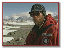
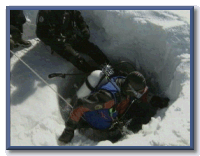
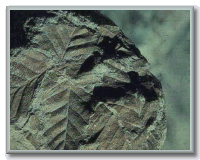
"Reading the Rocks" (06:11) This segment shows 2 geologists attempting to document Antarctica's past climate, in part, to provide a baseline upon which to understand what might happen in the future. Dramatic scenes of remote field camps and extreme conditions (note the ice encrusting Dave Marchant's beard!) make the tale of the "Two Daves" a compelling example of how science uses hard (in this case, rock) evidence to illuminate important but difficult questions. The Daves fundamentally disagree. David Harwood: "One view that we hold is that the ice sheet has been very dynamic: growing ice sheets, shrinking ice sheets, growing ice sheets, shrinking ice sheets, through time." Dave Marchant: "The volcanic ash story has told us that Antarctica has been a cold desert for 15 million years, and it's a frozen landscape." Students will see the two researchers marshal some of the evidence which lies behind and below their strongly held opinions. Harwood points out how layers in the rock contain evidence of what's older and what's younger, and shows us fossils of the diatoms and leaves he thinks prove Antarctica was much warmer and wetter just a few million years ago. At a still more remote 2-person field site, Marchant, by contrast, shows us volcanic ash trapped in distinctive cracks which he believes could only have been made if Antarctica has been locked in a perennial deep freeze for at least 13 and-maybe-30 million years. As Harwood concludes, in something that is the credo of true scientists everywhere: "The only way we're going to resolve these two different views, one a 'stablist' view, one a dynamic view, of the ice sheet, is by collecting more information. By working on these rocks that are here around us, by discussing the various bits of evidence, finding the weak points, posing the new questions."
Vocabulary
Concepts & Critters seismic waves, mantle, crust, geothermal heat, geologist, micropaleontologist, geomorphologist, plate tectonics, igneous, glacial deposits, sediments, rappelling, plankton, diatoms, sediment, stablist, dynamist (or dynamicist)
Proper names Central West Antarctica, Jamesway huts, Skidoos, Mount Erebus
Pre-Viewing Questions
Are older rocks usually found above or below younger rocks? (Usually older rocks are found below younger rocks.)
What's a glacier, and how fast can it move? (Glaciers are ice in motion, and-in the case of the West Antarctic ice streams, they are moving at the unusually fast speed of 2,000 feet a year.)
Why would anyone in North America be concerned about the stability of the Antarctic ice sheets, and Antarctica's climate history? (Because if some or all of the Antarctic ice melted, global sea level could rise by as much as 60 feet-see also program 8.)
|
|
Post-Viewing / Quiz Questions
How does Sridhar "see" through a mile of solid ice? (By using explosions to create seismic waves which he can then analyze via computer. The length of time it takes for the sound echo to bounce back up to his detectors helps him understand what kind of rock lies down below.)
What's the name of Earth's southernmost active volcano? (Mount Erebus)
What evidence does David Harwood use to tell him about Antarctica's past climate? (Fossils of diatoms-small microbes-and leaves.)
For at least how long does Dave Marchant think Antarctica has been locked in a deep freeze? (13-30 million years)
|
Discussion Topics
Why does David Harwood call himself a "garbage pile geologist"? (He uses the rocks that happen to have been dumped on the accessible surface by glacial movements as evidence.)
What evidence do the "two Daves", Harwood and Marchant, present for their conflicting views of Antarctica's past climate? (Harwood: fossils are found in layers of rocks which can be dated to a few million years back: leaves [and trees transformed into coal] could only have existed if the climate was then much warmer and wetter. Marchant finds ash from an eruption he can date at 13 million years ago, trapped in cracks which can only have been created and maintained if the climate remained much as it is today.)
Who do you think is the most convincing? (Answers here don't matter. Instead it would be important for students to be able to compare and contrast and evaluate the kinds of evidence the two Daves cite.)
|
Hands-On Activities
LIVE FROM ANTARCTICA Teacher's Guide, page 19, Activity 2 Fossils: Clues to the Past
POLAR CONNECTIONS Guide (NSF) page 30, Activity C1.1 Make Your Own Fossil and Activity C1.2 Polar Preserves, pages 32-33
(1-2 class periods for any of these Activities, and an additional ½ period to observe changes in Fossils: Clues to the Past: we suggest you check out each Activity, and implement the one whose procedures best fit your classes.) Through any one of these 3 Activities, students will demonstrate the ability to create a model of the layers of the Earth and observe the changes in objects trapped in their soil. Please also note the wonderful excerpt from Barry Lopez's description of the Dry Valleys found on page 19 of the LFA Guide, and the description of "paleobotanist" Edie Taylor on page 33 of the NSF Guide.
|
|
LIVE FROM ANTARCTICA Teacher's Guide, page 23, Activity 2 Staking out the "Real" South Pole (1 class period)
This Activity uses the "moving" (more strictly, the relocation) of the geographic South Pole as seen in this program to explore the motions of the Antarctic ice sheet over time. (Please note that you may choose to use this Activity to support program 7, Laboratory on the Ice, which focuses more specifically on the South Pole.)
Online
These 2 online Activities provide exciting ways to connect some of the research techniques seen during the video to hands-on experiences: well worth checking out and implementing.
http://tea.rice.edu/activity/tea_activity_shutey_intro.html
Through this Activity, students can demonstrate the ability to determine ways to make "observations" about unknowns, such as the land beneath an ice sheet or the interior of the Earth, using tools other than sight.
http://tea.rice.edu/activity/tea_activity_shutey_res.html
Please note that while Sridhar's research uses seismic or sound waves rather than radio, the principle of transforming travel time into a pattern of reflection still applies, and makes this a great way to understand how you can "see" through solid ice. In this online Activity students will demonstrate the ability to 1) become familiar with radio waves used to remotely sense topography beneath the ice sheet 2) experiment with travel time of waves and convert these to distances and 3), in groups, examine time data acquired along transects of the Antarctic ice sheet and convert these data to depth, resulting in a profile of the topography beneath the ice.
At the PASSPORT TO ANTARCTICA website, read BIOgraphies and/or JOURNALs from Sridhar, David Harwood and Dave Marchant in the RESEARCH/ers section.
Suggested URLs
http://www-bprc.mps.ohio-state.edu/
Information from the Byrd Polar Research Center, Columbus, Ohio
http://www.secretsoftheice.org/explore/past.html
Materials to explore plate tectonics, weather, ice cores, and current events
http://volcano.und.nodak.edu/vwdocs/vwlessons/plate_tectonics/introduction.html
A middle school lesson covering the chemical and physical layers of the Earth, historical development of the theory, and descriptions of the location and types of plate boundaries
http://pubs.usgs.gov/publications/text/dynamic.html
This Dynamic Earth: The Story of Plate Tectonics: complete text and figures from this book published by the U.S. Geological Survey
http://www.ees.nmt.edu/Geop/mevo/mevo.html
Mount Erebus Volcano Observatory: current data about the volcano and links to the field logs of a volcanologist working at Mount Erebus
Selected "NSES/2061 Benchmarks" met by the video, hands-on and online resources
2.3.2 Knows that sedimentary, igneous, and metamorphic rocks contain evidence of the minerals, temperatures, and forces that created them
2.3.3 Knows processes involved in the rock cycle (e.g., old rocks at the surface gradually weather and form sediments that are buried, then compacted, heated, and often re-crystallized into new rock; this new rock is eventually brought to the surface by the forces that drive plate motions, and the rock cycle continues)
2.3.6 Knows how successive layers of sedimentary rock and the fossils contained within them can be used to confirm the age, history, and changing life forms of the Earth, and how this evidence is affected by the folding, breaking, and uplifting of layers
2.3.7 Knows that fossils provide important evidence of how life and environmental conditions have changed on the Earth over time (e.g., changes in atmospheric composition, movement of lithospheric plates, impact of an asteroid or comet)
12.3.1 Knows that vibrations (e.g., sounds, earthquakes) move at different speeds in different materials, have different wavelengths, and set up wave-like disturbances that spread away from the source
14.3.3 Understands that questioning, response to criticism, and open communication are integral to the process of science (e.g., scientists often differ with one another about the interpretation of evidence or theory in areas where there is not a great deal of understanding; scientists acknowledge conflicting interpretations and work towards finding evidence that will resolve the disagreement)
15.3.6 Understands the nature of scientific explanations (e.g., emphasis on evidence; use of logically consistent arguments; use of scientific principles, models, and theories; acceptance or displacement based on new scientific evidence)
15.3.7 Knows that scientific inquiry includes evaluating results of scientific investigations, experiments, observations, theoretical and mathematical models, and explanations proposed by other scientists...
